FORT BUILT TO PROTECT THE SYMMES PURCHASE
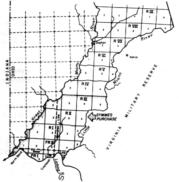
On November 18, 1788, 26 brave persons stepped off flatboats on the Ohio River and established the first settlement in Southwestern Ohio to inhabit Columbia, a community about a mile west of where the Little Miami River empties into the Ohio River.
The site today is in Cincinnati’s southeast corner, between Lunken Airport and Alms Park.
About a month earlier — October 15, 1788 — Congress had approved the sale of one million acres in the Northwest Territory to John Cleves Symmes of New Jersey.
Symmes is a familiar label on the area’s landscape, and most of the names are a tribute to the region’s first land owner and real estate agent.
John Cleves Symmes was born July 21, 1742, at Southold, Long Island, N. Y., and was residing in Sussex County, N. J., in 1770, before the start of the American Revolution.
During the war, he was a colonel in charge of New Jersey troops. He was on the committee that drafted a new state constitution in 1776, and was an associate justice of the New Jersey Supreme Court from 1777 through 1783.
He was a New Jersey representative in the Continental Congress from 1785 through 1787 while that body searched for a way to sell land and control settlement in the Ohio valley.
Congress, which was then the only branch of government in the new United States, adopted ordinances in 1785 and 1787 which opened the way for migration into the region that would become the states of Ohio, Indiana, Illinois, Michigan and Wisconsin.
In New York City, Congress adopted the Northwest Ordinance July 13, 1787, while in Philadelphia the Constitutional Convention worked until September on a new plan of government.
August 29, 1787 — less than seven weeks after enactment of the Northwest Ordinance — the 45-year-old Symmes asked his colleagues to permit him to buy one million acres in the wilderness.
Joining the often-controversial Symmes in the venture were Elias Boudinot and Jonathan Dayton, past and present members of Congress from New Jersey. Dayton also was then a member of the Constitutional Convention.
In the spring and summer of 1787, Symmes had traveled down the Ohio River to inspect potential locations.
His choice, because it was north of the Ohio River between the Little Miami River and the Great Miami River, was known as the Miami Purchase. It included a portion of what is now Butler County.
It wasn’t until October 15, 1788, that Congress approved the sale to Symmes. By then, Symmes had been appointed to one of five administrative positions in the territory. February 18, 1788, Congress named him one of three territorial judges.
He planned to buy a million acres and profit by reselling smaller parcels to others. First, he priced his land at 66 and two-thirds cents an acre. Later, the standard price was $1.
John Reily’s First Stop in Ohio
Symmes quickly sold several thousand acres to Benjamin Stites, who a few weeks later guided the pioneers on the two-day trip from Limestone (now Maysville, Ky. ) to Columbia.
Stites had been with Symmes and others in September 1788 during their inspection of the land north of the Ohio River between the Little Miami and Great Miami rivers.
The first, task for Stites and others who arrived at Columbia in November 1788 was to build a small fort for protection from possible Indian raids. Of course, log cabins also had to be constructed before the onset of winter.
But food was more of a problem than shelter that first winter. The settlers soon consumed the food they brought with them. Then they had to rely on wild game — which was plentiful — and what they could extract from the ground.
According to one account, Columbia women and children had “to scratch up the bulbous roots of the bear grass, which when mashed, boiled and dried, were pounded into a kind of flour which served as a tolerable substitute for wheat and corn flour.”
The food situation began to improve in the spring when crops could be planted. But not all of the settlement’s manpower could be devoted to farming. Half of the men worked in the fields while the other half stood guard against Indian attacks. The groups switched responsibilities during the day to break the monotony.
Columbia residents suffered another setback in November 1789 when the Ohio River flooded the community. Only one house escaped the water.
Columbia survived the hardships and prospered. It quickly became a trading center — thanks to an adjacent area known as Turkey Bottom, which produced high yields of corn each year.
At first, Columbia grew faster than nearby Cincinnati (to which it was annexed in 1873), and North Bend, a settlement started by John Cleves Symmes.
A missionary who visited the three river communities in 1792 said Columbia had 1,100 inhabitants while Cincinnati had about 900 and North Bend between 300 and 400 residents.
The first school in the Symmes Purchase was established at Columbia In June 1790 by 27-year-old John Reily, who was also an Indian fighter and soon became a leader not only in Columbia, but in the Northwest Territory.
Thirteen years later Reily — a native of Pennsylvania who spent his youth in Virginia before service in the revolutionary army — would move to Hamilton and continue to serve in various official capacities until a few years before his death June 7, 1850, at the age of 87.
A Campaign Against the Natives
Attempts to settle Ohio began in 1788, but migration across the Appalachians into the area was slowed by Indian resistance. Building log forts on the banks of the Ohio River at Marietta and Cincinnati had failed to intimidate the Native Americans, and in 1790 an ill-prepared military expedition ended in defeat.
In 1791, Congress — at the urging of President George Washington — authorized an increase in the army and the militia to challenge the Indians again.
At the same time, Arthur St. Clair — governor of the Northwest Territory since 1788 — was appointed major-general and commander of the U. S. Army. St. Clair, based in Cincinnati, hoped to gather 3,000 men for another campaign against the Native Americans residing later became western Ohio and eastern Indiana.
One of his objectives was to build a series of forts extending north from Fort Washington in Cincinnati. Execution of that strategy led to the building of Fort Hamilton.
The task was assigned to Lt. Col. William Darke, who also was responsible for cutting a road through the wilderness between Fort Washington and the first in a chain of “forts of deposit,” the 1790s military term describing supply posts.
In August, Darke ‘s advance unit established a camp at Ludlow Station, five miles north of Cincinnati on Mill Creek. On September 6, 1791, Darke’s soldiers started for their destination, about 25 miles north of Fort Washington. It took three days to chop through the thickly-wooded countryside.
Darke made camp near the present site of the Columbia Bridge in Hamilton and waited for orders. September 20, St. Clair ordered Darke to proceed to erect the fort on a site which had been selected during a previous scouting mission.
Built with 80 Axes and a Saw
The location on the east bank of the Great Miami River was chosen because the army planned to transport supplies from Cincinnati via the river. The site also was at a ford, a natural river crossing, which had been used by the Indians. It is believed to have been on an alignment with present Ross Avenue and Court Street. The fort’s gate was at this point, opening to the west.
About 100 men worked for two weeks to complete the fort, then about half the size of a modern football field.
From the surrounding woods, the men and their oxen combined to cut straight, 20-foot logs and drag them to a flat area beside the river. The timbers — from 9 to 12 inches in diameter — were placed upright in a three-foot trench around the perimeter.
Four blockhouses or platforms were built, three on the land side and one facing the river.
Inside the fort, soldiers built a barracks for about 100 men, a guard room, two storehouses and a magazine.
Darke’s contingent faced a familiar military problem — a shortage — according to the adjutant general of the army.
“The provisions of tools . . . was scanty in the extreme,” said Col. Winthrop Sargent in his diary of the campaign. “Eighty axes only were furnished by the quartermaster, and of these 13 were borrowed from the troops.” Sargent said the crew had “one saw and one frow” (a wedge-shaped cleaving tool).
September 30, 1791, is regarded as the completion date for the crude fort which was named in honor of Alexander Hamilton, then secretary of the treasury in President Washington’s cabinet.
The fort — which would be enlarged later — immediately became the temporary base for about 2,000 soldiers, considerably less than the 3,000 that St. Clair had anticipated. Oct. 4 — five days after completion of Fort Hamilton — Gen. St. Clair led his hastily-assembled army out of the frontier outpost toward a showdown with the Indians.
‘The Miami Slaughterhouse’
Unfortunately, many of John Cleves Symmes’ deals were faulty.
There was confusion between Symmes and the government over both the size and the boundaries of the Miami Purchase.
In some cases, Symmes sold land which he didn’t own. Some problems were attributed to Symmes’ tendency to neglect details, including selling tracts on credit and then failing to collect payment.
The labeling of his real estate as “the Miami Slaughterhouse” — because of deadly Indian raids on settlers — discouraged some prospects from buying Symmes’ land.
Added to all of their troubles were disputes between Symmes and some of his associates.
In March 1811, a mysterious fire destroyed Symmes’ residence. Eventually, his holdings were seized and sold to satisfy legal claims against him.
Symmes, then 72, died in poverty February. 26, 1814, in Cincinnati. He was buried with military honors in North Bend, an Ohio River community which he founded February 2, 1789.
Culled from the following columns at the Lane Libraries Jim Blount History Resources Archives:
Sept. 25, 1988 – Hamilton once army fort:
Nov. 13, 1988 – Early settlers busy beavers:
April 22, 1990 – First land owner died poor:
Current Column: Sugar first food rationed during World War II; Backyard Victory Gardens and Victory Flocks suggested to supplement local food supplies



 Cincinnati Land Office Records


 Article taken from "Backsights" Magazine published by Surveyors Historical Society